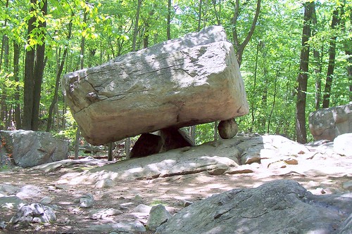
Tripod Rock is glacial erratic or "perched boulder" located in Kinnelon, New Jersey in the Pyramid Mountain Natural Historical Area. This famous multi-ton Precambrian gneiss boulder, located near the edge of a long ridge, is balanced on three smaller boulders. It is roughly 6 meters long, 3 meters wide, and 2.5 meters high (~19 feet, 10 feet, and 7.5 feet). Its weight has been estimated as approximately 127 metric tons (140 tons). There is a peculiar triangular crest running the length of its top. The entire boulder is balanced on three smaller stones between roughly one meter in diameter that raise it above the bedrock by about 0.5 meters at its lowest point. The point of contact between the main boulder and its support stones form an approximate 3-4-5 triangle.
About 12 meters northwest from Tripod Rock are three boulders that appears to form a triangle. The two largest boulders are balanced partially on smaller stones (see diagram). The apex rock is about 3 meters away to the northeast. Sighting from a bedrock outcrop near Tripod Rock through the two large boulders, the apex of the triangular configuration points to the next ridge on the horizon to the west. Intriguingly, it has been observed that this line of sight forms the setting point of the sun on the summer solstice. During the early 1980's Tripod Rock and the stones near it were surveyed and the place on the ridge where the sun sets at the summer solstice was visible due to gypsy moth defoliation.[1] It was noted that a large boulder was located at the top of the ridge at the place of the summer solstice sunset. Within a year of the survey a home was constructed on that site and the rock was displaced by earth-moving machinery. Today the sun sets against the far ridge near the edge of a residence and is only partially visible.
There are also two smaller perched boulders found to the northeast of Tripod rock (not shown on diagram) that measure approximately 1 to 3 meters in diameter. No specific calendar alignment has been noted. Tripod Rock stands on a ridge overlooking a long valley where a massive glacial erratic named Bear Rock is located near a brook. Bear Rock is said to have been thoroughly excavated for archaeological artifacts in the 19th century, some of which are reported to be owned by museums, though this has not been verified. Bear Rock has a large overhang making it a possible rock shelter.
While there is no evidence that Tripod Rock was ever used as a solar observatory, it could function as one if a small portion of the ridge across the valley were kept clear. Tripod Rock is presumed to be a natural, though highly unusual, glacial erratic. It is comparable to the balanced rock in North Salem, New York. Some have suggested that Tripod Rock was modified or adjusted into its present position by lifting and inserting successively larger stones. A local legend suggests it was levitated into position by Native Medicine. While the later explanation is highly unlikely, the Tripod Rock site is located in a region that once had a large Native American population and it is possible that some form of calendar keeping utilized the horizon features of the area. Source: Wikipedia

20120103
Tripod Rock
Subscribe to:
Post Comments (Atom)
No comments:
Post a Comment